
There is a small and fascinating park in the northernmost part of California dedicated to learning about and exploring a volcanic landscape. The Medicine Lake Shield Volcano is the largest of its kind in the Cascades Range of the Western United States. It covers 770 square miles (2000 km2) and the national monument occupies only 10 percent of that area but within that 10 percent shows visitors a range of geologic outcomes of this type of volcanic activity. Petroglyph Point, which we had explored in the morning (and covered in my previous post), was created about 275,000 years ago when cinders erupted through the shallow water of ancient Tule Lake. Ash and steam erupted time and again, forming hills of tuff layer by layer.
Shield volcanos are so named because they spread out relatively flat upon the land and the gentle lava flows cover a circular area with a gentle slope, resembling a defensive shield lying on the ground. 500,000 years ago cracks opened in the earth and released liquid rock, called lava, at this place. These eruptions continued over thousands of years, leaving fields of black lava rock, tunnels, caves, craters and cinder cones. The most recent eruption here was 950 years ago, and it’s still a living volcano, meaning that another eruption is likely in its future.
I was dismayed to find out, prior to the trip, that some of the trails I was most interested in exploring were closed as a result of wildfires during 2020. The trails have not yet been made safe for visitors. I quickly recovered from disappointment. We didn’t really have to time to explore deeply, since it was our last day of touristing before we needed to return home. Our hotel that night was a four-hour drive away, so we would need to leave the park with enough time in the day left to get there before we fell asleep. We left Petroglyph Point and drove south all the way through the park to reach the entry gate. I pulled to a stop at the window and reached for my purse to purchase a park pass, and asked if there was a discount for military veterans or veteran retirees. The park ranger said, “Today is your lucky day!” He explained that just recently, Congress had voted to make free park passes for life available to all U.S. military veterans. I handed him my military ID card, and he handed over the park pass, a rearview mirror display card, and a brochure explaining it all. He told me my entry into every national park and national monument in the country is now free. Wow! Serendipitous!
Pedro had explained to me that there are lava tubes that people can explore here – another thing I didn’t know before coming. We reported that our interests were the caves, and Modocs, and the park ranger handed us additional brochures with general park information, cave exploring information, and a brochure with a brief history of the Modoc people who lived here and the war that occurred on this land. He asked us some pointed questions about our history of visiting caves, in order to protect the park’s bats from White Nose Syndrome (the goal is not to wear shoes from one cave into another cave, that way people don’t accidentally spread the disease), determined we were safe, and sent us on our way.


We were able to walk a couple of short trails and get a good sense of the land. It seems inhospitable, but I could see the appeal to the Modoc people. The rocks are rough and thus very easy to climb. Your feet do not slip. The rocks support plenty of wild flora and fauna. In the brutal summer sun, there are caves and tunnels that stay cool and trap moisture.
One interesting trail was to a spatter cone called Black Crater. A spatter cone is a low, steep-sided hill or mound that consists of welded lava fragments, called spatter, which have formed around lava issuing from a central vent.


These lava fields and nearby Lost River and Tule and Lower Klamath Lakes are the traditional homeland for the Modoc tribe, who were here for thousands of years before European miners and settlers arrived in droves and demanded that the U.S. Army remove the Modoc to a reservation shared with their traditional enemy, the Klamath tribe to the north. Major Fitzgerald led a group that found and destroyed all their winter supplies putting the Modoc people at their mercy. An Indian-hunter, Ben Wright, was paid by the state of California to kill Indians, and he ran up a white flag of truce to trick Modocs into joining him for a feast, where his men killed as many as they could. After the murders and the loss of their winter food, the Army was able to forcibly remove them to the reservation. The Klamaths outnumbered the Modocs and treated them badly and many of the Modocs left the reservation and returned to their own lands. The Army again tried to bring them back and during the winter of 1872-73 about 60 Modoc men took their families and went to hide in the lava beds. The land was forbidding and dangerous to anyone who didn’t know it, but the Modocs knew it intimately and successfully held off the Army. General Canby and his men ran up a white flag, and invited Modoc leaders to peace negotiations in a tent on the battlefield. The Modocs remembered their history of being tricked by a white flag, and met the General reluctantly and suspiciously. When Canby denied them their own land, Chief Kientpoos shot him and two others. General Canby died, outraging the American public and renewing the Army’s dedication to exterminating or overpowering the Modocs. Chief Kientpoos was captured and hanged and his head severed and sent to an Army hospital to be studied.
Though fires forced the closure of the most historically significant trail relating to the Modoc war, a few sites remained open.

The Canby Cross is a replica of the original cross erected nine years after the General’s death, including the same inscription. When I was close enough to read it, the words on the cross were hurtful, and I did not take another photo. There is a plaque nearby that provides context, and I think an example of what many wish for in the United States regarding the conflicts of emotions surrounding Confederate soldiers and leaders: leave the monument, but add a plaque to provide context. Say, in essence, “This is why some people want to commemorate this event/person. This is why it is offensive to others. Here are some more things to think about.” The plaque here acknowledges the words on the cross. It ends by stating, “No monument commemorates the places where Modocs may have felt their attempts to live peaceably were betrayed. More than any other Modoc War site, the Canby Cross represents the vast gulf between the perceptions of the two sides during war time, and challenges us to look beyond history to the assumptions of our own cultures. As in all wars, there were no innocent parties in this conflict.”
Because of our short visit, and because of the closed sites/trails, I plan to visit again in the future when it’s open again, and spend an entire day here, learning more about this one sad chapter of my probable ancestors.
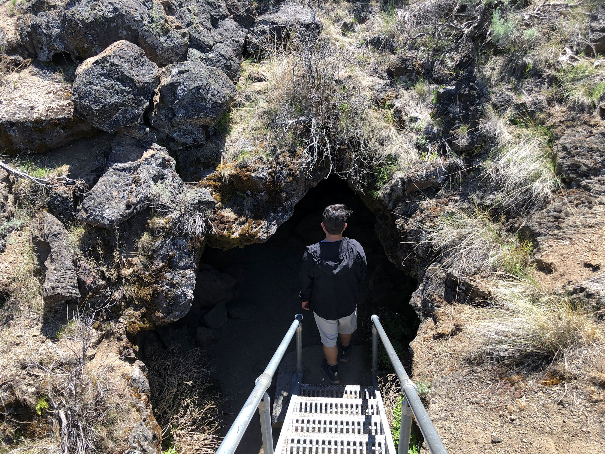
Our last stop was the visitor center, home base for caving! At the Visitor Center, people were crammed in line, waiting to check out free helmets and large flashlights. What a great service provided by the park! Pedro and I decided to skip the lines and rely on our hard heads and our phone flashlights. We explored a couple of caves around the visitor center. One, called Mushpot, is the ideal beginner cave. It is paved, well-lighted, and filled with information signs and warnings to duck under low rocks. Children and people who are not steady on their feet in the dark are the right people to explore Mushpot. It’s also the best cave for photographing, when all you have is your phone camera.


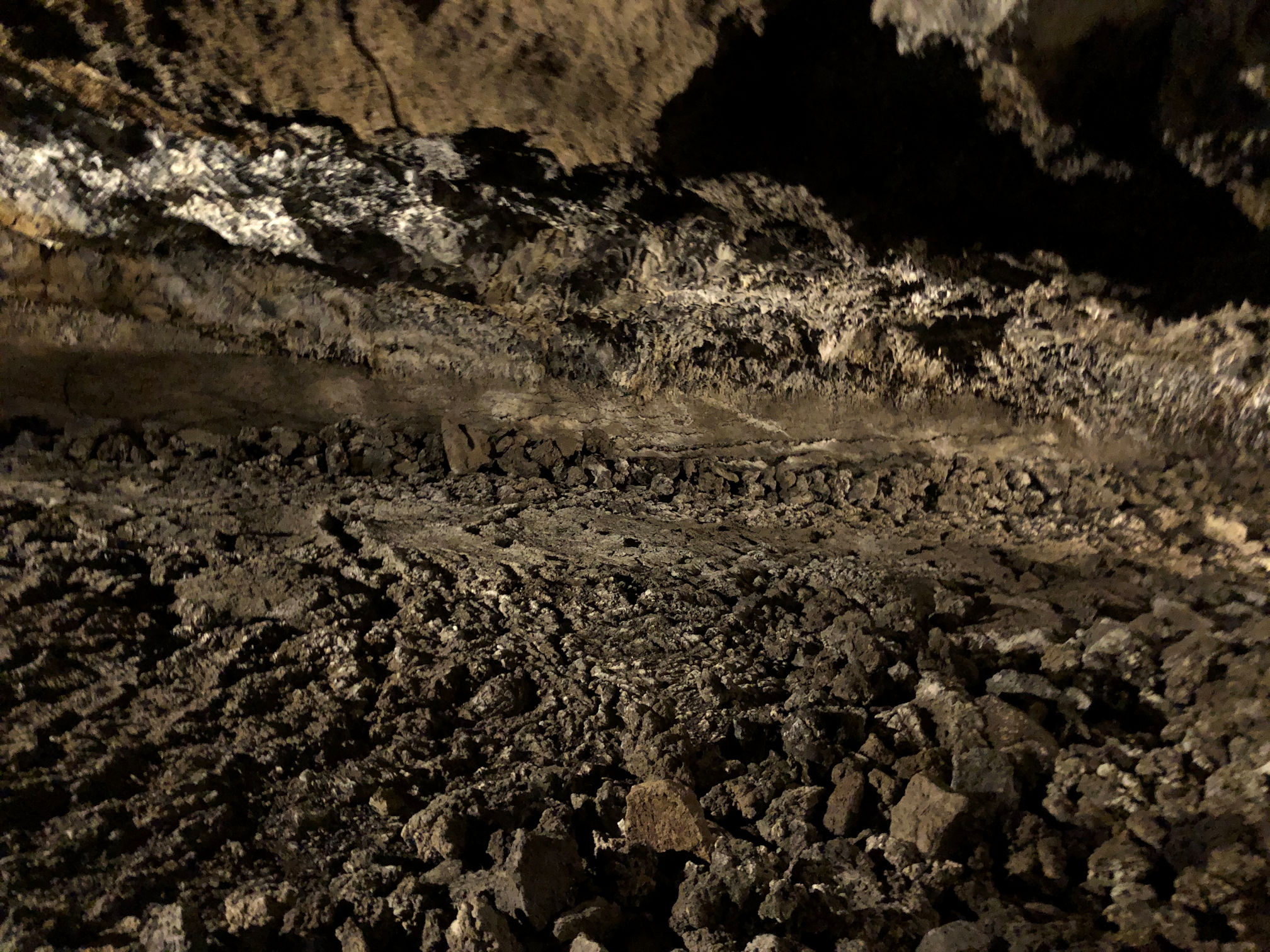
Just outside the parking area is a loop drive that provides access to 12 caves. These caves were formed from 65,000 to 10,500 years ago.
Lava tubes, or lava caves, are formed when a river of lava flows over the ground. It’s thick, and flows in the shape of a flattened tube. The outside of the tube cools quickly when it is exposed to the air, while the inside of the tube stays hot and continues to flow. When the source of the lava flow stops, the hot stuff inside flows out the other end, leaving an empty lava shell. The lava tubes nearly always grow smaller and smaller, as the amount of lava is reduced, until there is no more tube formation. People explore these caves because they often have a floor smooth enough to walk on and a roof high enough to stand upright. At least at the beginning. Near the end of the tubes, people like to crouch, and then crawl, to see how far into the tube they can get.
Pedro and I chose not to go too deeply or crawl on our bellies too much, because of our lack of equipment. We stayed comfortably close to openings.


Hot, tired, and happy, we climbed into the car and drove north after that. We stopped for lunch at Diamond Lake, a resort area that Pedro knew pretty well and I recalled vaguely from childhood. We stopped briefly at one more childhood home: this time it was where I lived from age 2 to age 10. We drove through the small town of Glide, Oregon, where I attended 1st-4th grades. We stopped for the night in Roseburg. The next morning we had an easy four-hour drive home.
Thanks for coming along with us on our first road trip of 2021! And because of the pandemic, only my second road-trip since 2019!

I’m so happy for you that you had a lovely road trip, and that now you have all the monuments and nature reserves free!! Is this valid all over the USA? How great is that?
This is not so nice at all: “being tricked by a white flag”. 😦 It made me sad and angry.
The scenery is quite alienesque. In Europe, in a space this size, there would be 7-8 small-size countries. 😀
Seven to eight countries could cover one shield volcano? It’s hard to imagine that. And carry that scenario out a little farther: what limited resources for a country made up of black rock, sagebrush, and lava tubes. Ha! I guess they could get creative and capitalize on what they had: tourism, or maybe selling the rocks for landscaping, artificial climbing walls, or for winter roads. Hey, do they use that in the mountains there? It’s common here to use ground up volcanic rock on icy roads, since it’s really so rough and grippy for tires (and feet).
Yes! The pass is good all over the USA. This is such a wonderful gift from Congress and I hardly know how to begin using it to make the most of it. I might need to just start taking constant road trips. There are still a few states in the US I have not visited, and I have never found a National Park or National Monument that I wasn’t impressed with. I might have to leave Pedro in the dust because he needs to be all responsible and work Mon-Fri. But I can take off with no obligations! In the future, I will remember to bring my gosh-darned camera. 🙂
Hahha, I was exaggerating with the comparison. 2000 km2 sounded a lot but now I see that only Luxembourg measures this much. 😀 Interesting use of volcanic rock. Sounds that it’s working too. This pass is made for you. I’m really glad that your country thought of this.
Oh yes, and the white flag bit. Doesn’t it just make your blood boil? Also the part where it was Autumn, and the Major went and found their whole winter supply of food cached away, and destroyed it all. This almost guaranteed the whole tribe would starve that winter. How wretched. So then when they “agreed to peace talks,” with Ben Wright, it wasn’t really an agreement, more like they had no choice. Then he went that extra step and tricked them with the white flag. Arrggh. It’s clear that these acts can only be done around the world when someone views the enemy as less than human.
😦 Just horrible.
We might have literally bumped into one another there ! I was there on Monday. Cool place, I love all this info. I may have to link to your blog when I finally get one written. Great post !
Thank you! Bonnie, that is so neat that we were both there at the same time! I am late posting, so we missed each other by two weeks. I am glad you enjoyed the background information, and how much more relevant it must be to you because you can easily picture the place. I hope you enjoyed your visit there.
An awesome area well documented with prose and photography. Very distressing detail about your ancestors
I appreciate the compliments, Derrick. Yes, the story is distressing but I’m using my blog as a platform to keep telling the stories. I know you have already heard the long version, but if anyone new is here, I want them to learn a little more about US history.
Of course
Great post. I collected lava at the top of Mount Vesuvius but that didn’t involve going underground.
Thanks, Andrew. Do you still have the lava you collected? That is very cool. If there was a lava tube available, would you be willing to explore it with flashlights and headlamps?
Did you catch any of the pictographs that are found at the entrance of a couple of the caves, Crystal? Some fun going inside, huh! I really liked the photo of you where you were using your cellphone for light. And the history is so sad, and so wrong. –Curt
The ranger at the entrance told us to look for them, but we did not notice any. I think it’s because our trip was quick. We will go again and leave a whole day for exploring the caves. I think there might be enough to find more with every visit. It seems to be one of those kind of places.