Since I’ve been traveling to Annapolis every year for seven years, I’ve explored everything within walking distance of the hotel. This includes the city of Annapolis, and most of the tourist stuff to do there, like the State House and the William Paca House, the waterfront, the Naval Academy several times. I’ve even visited the Luther A Palmer Memorial Cemetery that is directly in the middle of a median in the road – apparently there long before highway improvements. I’ve hiked the nearby trails so many times; Broad Creek Park and Waterworks Park.
This time I was willing to buy an Uber trip to go hike somewhere else, and I chose Patapsco Valley State Park because photos indicated that it has some more unique land features than the places right around the hotel. There was supposedly a waterfall, and some rock outcrops.

Elk Ridge Landing, established in 1690, was a prominent colonial deep-water port. It was the place to ship tobacco, grain, lumber and iron, and later cotton and flour. Elk Ridge Landing silted in because deforestation allowed dramatic erosion and it was no longer a serviceable port by 1868. What I find most interesting is that the sign denotes a port, and there is not much here anymore except apartments.

Maryland’s oldest state park, Patapsco Valley State Park extends along 32 miles of the Patapsco River, encompassing 16,043 acres and eight developed recreational areas. It is the site of some of Maryland’s earliest mills and factories, America’s first common-carrier railroad and the world’s first underwater hydroelectric plant.

I took my heavy camera to Maryland specifically for this hike. It weighed down my bags all week, but I knew it was going to be worth it; especially if I was able to see some wildlife. Then, naturally, I completely forgot all about the camera until I was halfway to the park in my Uber. Dang it!! All photos herein are thanks to my iPhone.

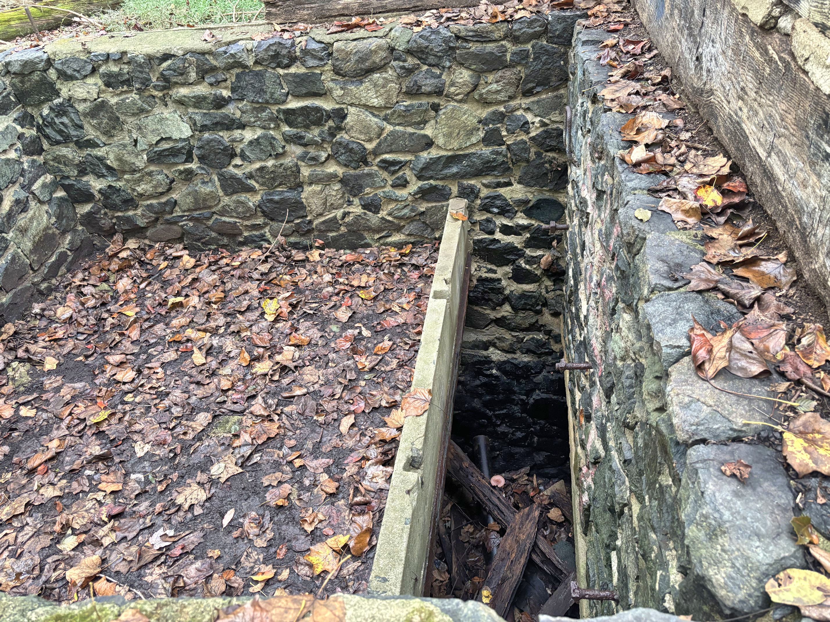
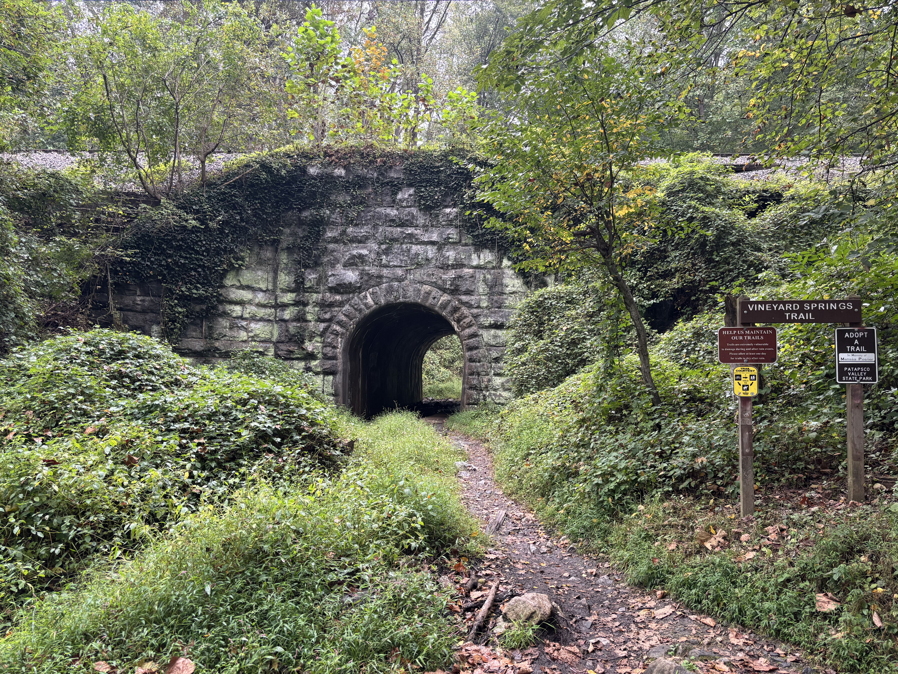
On my AllTrails app, I saw the location of the Avalon Dam marked. Not knowing anything about it, I set off on a mostly disused trail, dodging stinging nettle plants, and came out at a crumbling rock wall. Thus I learned that the Dam is a historic structure. Tropical Storm Agnes wrecked the dam in 1972 due to flooding. In the photo above, to my right is the river, so I turned left and walked the length of the wall that is there, following the “trail” on the app, and realized the only way to continue the trail was to climb over the top of the dam. So I did.

As you can see in the image, the dam is not terribly high. But the photo does a disservice, because the top was well over my head when I stood at the bottom. I did manage to clamber over it quite easily despite not being prepared, and wearing only a tennnis skirt, I did not skin my knees.


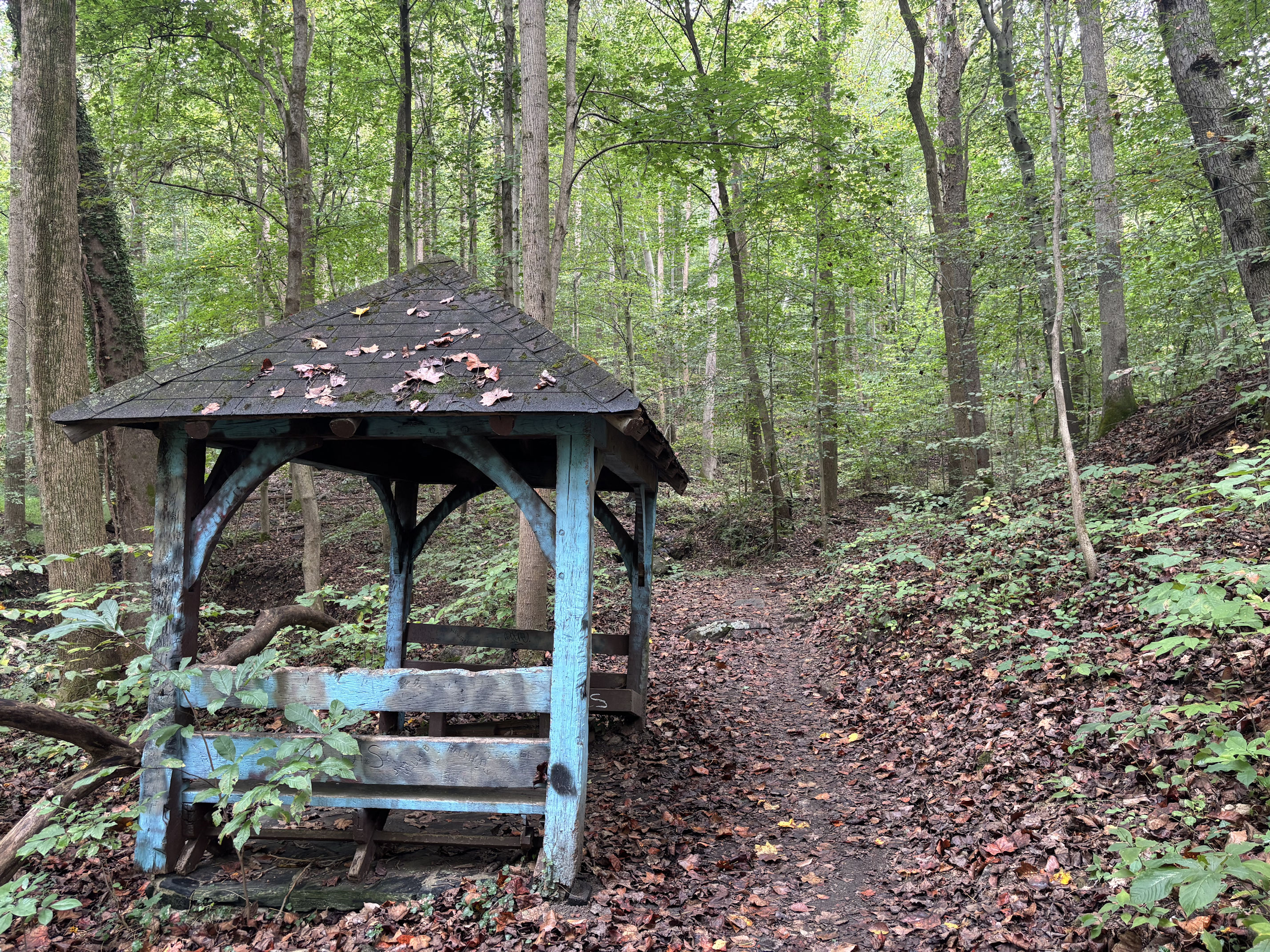
It is clear this region has been used in different ways over the decades. I found many signs like this damaged picnic shelter and broken footbridge in the photo above.


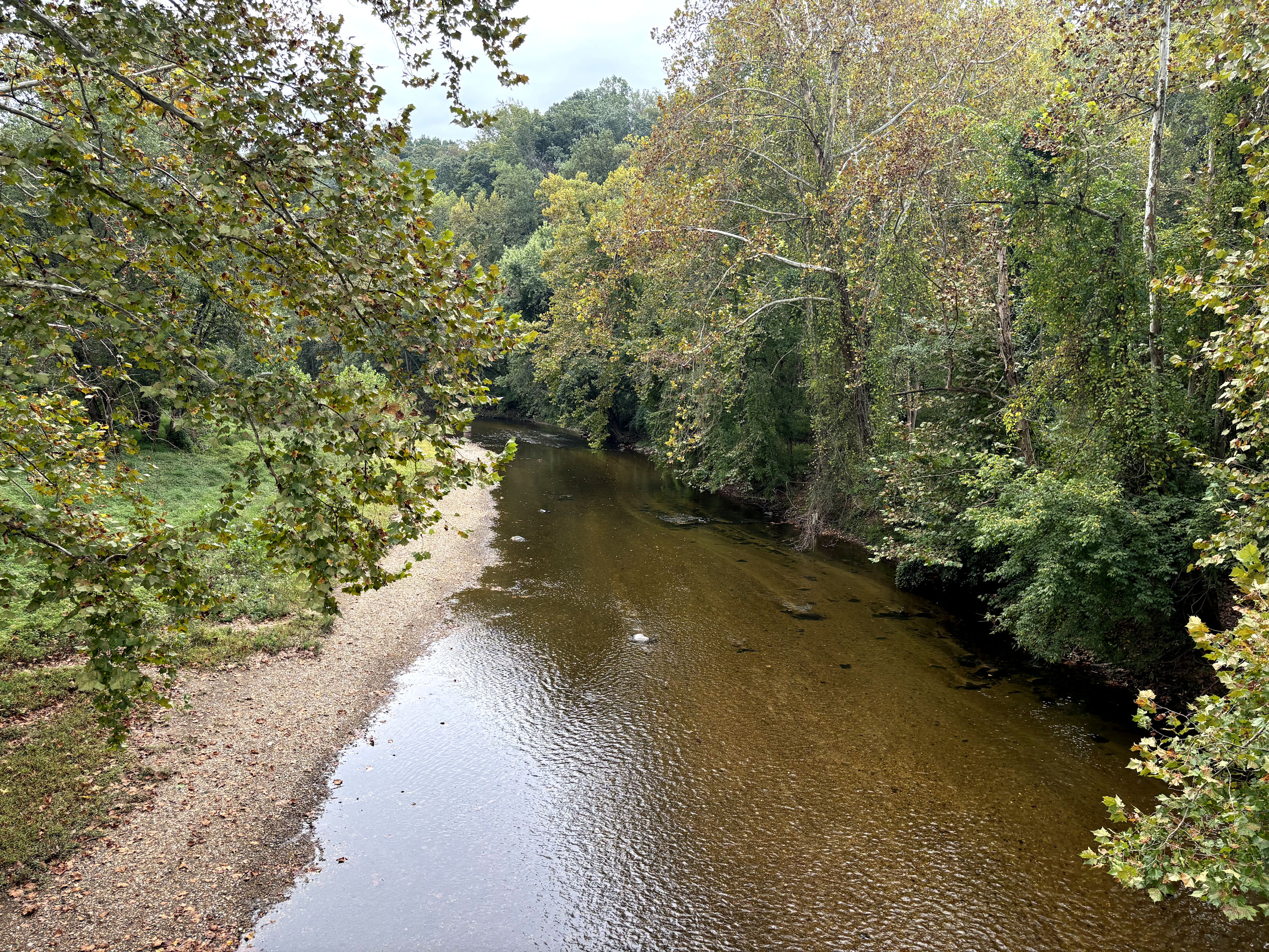
Late September showed Autumn colours beginning to emerge, but there was still much green in all directions. Maryland is a very lush and green state much of the year.


The most beautiful mushroom I think I’ve ever seen is this Amanita Ravanelli, if I have identified it correctly. It was absolute perfection of symmetry and magical delicacy about 7 inches high. The Aralia Spinosa towered high overhead, reaching bright magenta hairdos up to the light filtering down. They made me think of alien beings, these two slender giants walking side by side, superior to me, the little Earthling.
I saw a fox!! I was stopped on the trail, looking around, and this very dark and fluffy fox emerged after climbing up a hill to the trail. It saw me and hesitated, then calmly trotted down the trail away from me before darting back down the hill. My “camera” was, of course, in my back pocket, and it took me a long time to get it out and open the camera app, etc. By that time, I had no chance of capturing the beautiful animal. If you trust me, you can see that I really did capture a poor image of a fox in the photo below, just before it disappeared over the hill.


Halfway through my hike of 8.5 miles (13.5 km), my phone battery had dropped to 20%, so I thought it would be smart to turn it off. The problem then was that every time I wanted to take a photo, I had to press the button and wait for it to turn back on, then log in, then open the app, THEN take the photo. Despite all those painfully slow steps, this deer held still long enough for me to take her picture.
Finally I reached the waterfall, which was one of the reasons I had chosen to come to this particular set of trails.

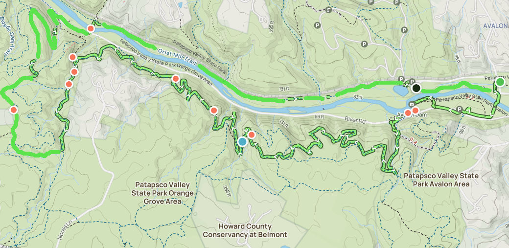
In the map above, you can see that I began confidently from the east side, at the green dot, and left my phone on while I hiked. The AllTrails app tracks my progress in a green line outlined in black. The red dots are where I took photos that you see here in this post. A couple hours in, I turned off my phone. While making this blog post, I used my photo editing software and drew in the bright green lines for all the times when my phone was off, and not recording my path. You can see I crossed the river and returned on the north side, along the Grist Mill Trail. The red dot on the far left of the image is where the deer was.

I turned uphill and began the Cascade Falls Loop Trail next, and when I came out again at the Orange Grove Area, it was at the swinging bridge.

The original swinging bridge was built in 1856 to allow residents to cross the river to the small rail station on the other side. Orange Grove Mill, who manufactured Patapsco Superlative Flour, built the bridge. It burned in 1905 and the current bridge was built in the 1970s.


On the other side of the river I followed the Grist Mill Trail, that is wide and flat and paved. There were cyclists and lots of young women, likely from a high school running team, all hitting the trail after work and school.
I had experienced a few drops of rain here and there for the past few hours, but on this final stretch, the rain began to come down steadily. Luckily, it remained light and the temperature was rather warm. None of the people using the trail seemed concerned about the rain, nor was I.

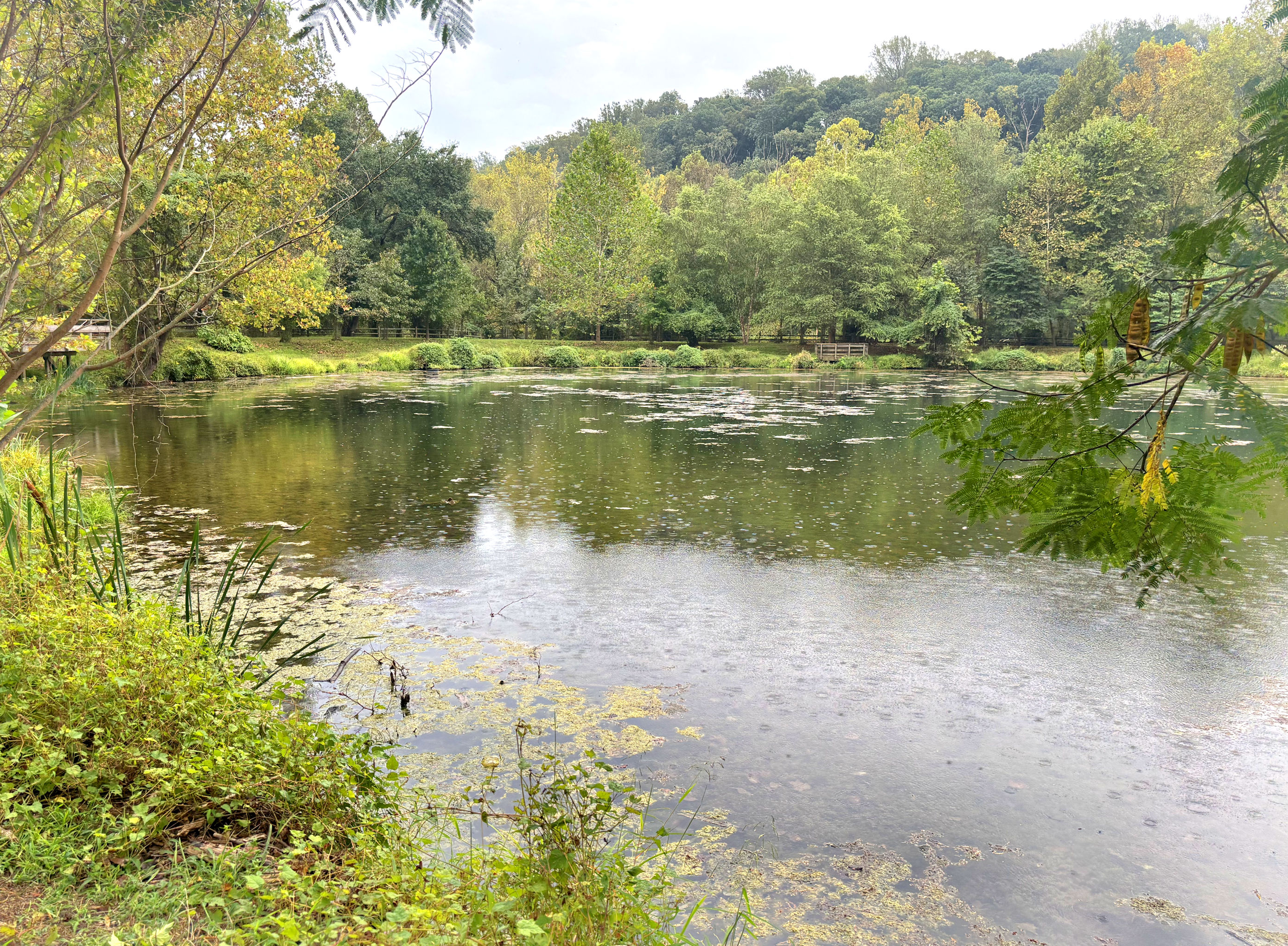
Next I came to Lost Lake, so-named because late in the season, algae can cover the entire surface, obscuring the water. Remember Avalon Dam from the beginning of this post? I had finally reached that spot again, only this time on the other side of the river. When Tropical Storm Agnes came through in 1972, it destroyed the original Lost Lake. The current lake is man-made and was rebuilt after the storm.
Finally, finally, I was back at the start, and the parking area for a visitor center. I knew it would be closed, because the Internet said it only opens on weekends, but I did want to take a look. I thought it was this pretty house:

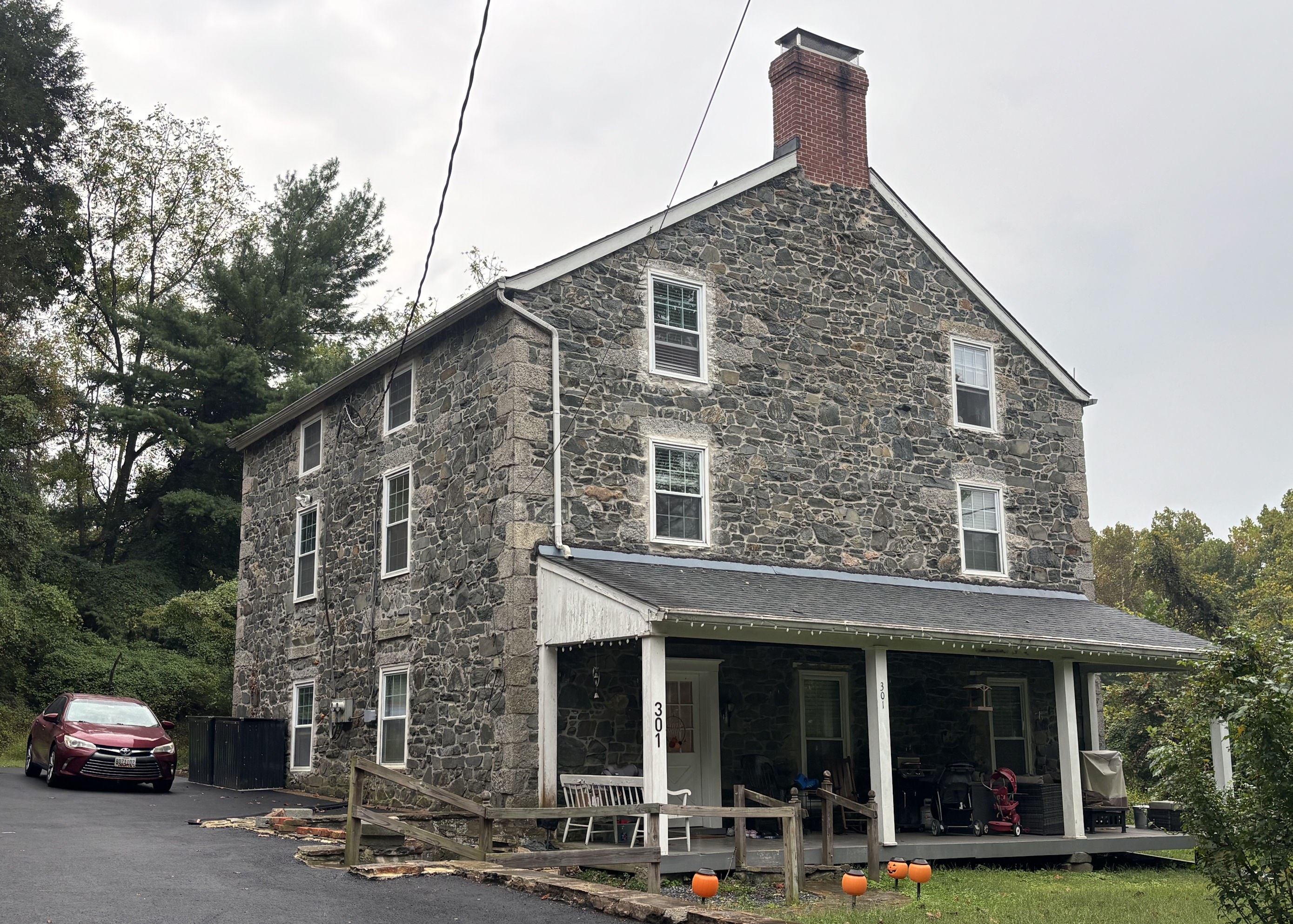
So I turned around and looked for a different house.

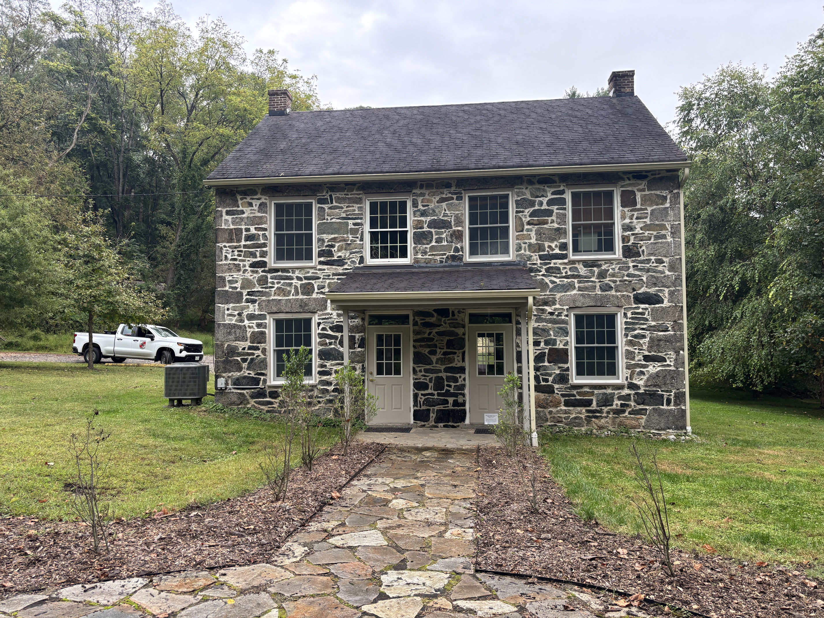
The place is quite pretty, and I would love to be able to go inside one day. The William Offutt Johnson History Center is one of the few surviving buildings from Avalon Iron & Nail Works. I am pretty sure I have not seen a stone duplex this old before, but that is what it is. Built in the 1830s, this was home to at least two families employed by the forge, which operated nearby from 1761 to 1868.

Though the rain was light, I was getting pretty wet after three and a half hours on the trail, wearing only a summer top and a tennis skirt and sneakers. I turned my phone back on. This is what I had been saving the batteries for: enough juice to call an Uber and get back to the hotel. I ordered the Uber. It said it was 11 minutes away. I messaged the driver and said I was already there and waiting, but my phone was dying and I had to turn it off. Then I did that.
Ten minutes later, I turned it on again to watch the Uber’s progress so I would not miss it. This time it said the car was 12 minutes away. The car had not moved, according to the map. It was still sitting at the Baltimore airport, as it had been when I ordered it. My battery was down to 8%. I waited, and watched, and the car did not move. I messaged again. “Is there a problem? Why aren’t you coming to get me?” I turned off the phone again.
Another ten minutes later, I turned it back on. 6% battery power. The app said the car was again 11 minutes away. The car had still not moved from the Baltimore airport. I got anxious. I took a screen shot of a map showing my location, and sent it to my teacher friend Vicki who was at the hotel. I told her what I could. I told her to expect a message from me in an hour and a half, and if she didn’t hear, then I was stranded. The Uber driver did not respond to my messages, which was strange, because they always had done so quickly in the past. I turned off the phone.
Another ten minutes later I turned it back on and FINALLY the car had moved and was close. I kept it on and was able to meet the car as soon as it arrived. I was so irritated and frustrated that I didn’t even know what to say to the driver. He didn’t say a single word. No apologies, no explanation. I sat there fuming, but desperate for a ride, so I didn’t complain. My phone died as I sat in the back seat, but I did message Vicki just before then to tell her I had been picked up.
It is the first time since I began taking Uber rides years ago, that I didn’t give a 5-star rating. The drivers are always great for me. I did some research online to try and figure out why a driver would not move for 20 minutes after accepting a ride, and there are a few reasons for a delay, but not for that long. I never did rate him. Or give a tip, and I always tip. But that’s his fault.
Anyway, it all turned out fine and I was safely returned in an hour to my hotel, still damp but in good spirits. It had been an excellent adventure.
Most of my historical facts came from this website: https://dnr.maryland.gov/publiclands/pages/central/patapscovalley/history-patapscovalley.aspx

This post brought back a ton of memories. whenver I was basing my adventures in the Baltimore area I’d visit Patapsco. But my recollection was the in the 60’s the recreation areas were pretty well maintained.
It’s great that I visited an area that you used to spend time in. To reassure you, the main recreation areas are today in pretty good shape. I only photographed the decrepit spots, where few people would be tempted to go. I guess without explaining it, I gave the wrong impression entirely. Today there are very large covered areas, bathrooms, parking lots, and picnic tables, at regular intervals along the paved road in the park. It is good to know that this beautiful area has been appreciated by so many people for so many years.
Looks like a fun walk, Crystal. Sorry you forgot your camera. Not as bad as leaving mine behind in Cairo when we headed up the Nile. That was a bummer. But it’s impressive what one can do with an iPhone when necessity calls! You did well. We really are going to have to get out and about around here more. Rarely being at home doesn’t help. I’ve actually done a fair amount of wandering in Maryland north of Bel Air and Jarretsville. My Great Grandfathers to the 5th and 6th hung out there in the 1760s up through the end of the Revolutionary war where they had a grist mill.At the Bel Air genealogy center I actually found over a hundred documents that they created over that time period. What a treasure.
Curt, that is indeed a treasure. Give yourself a break about exploring your neighborhood. Better to do the big stuff while you have the energy. When you get tired out, that’s when you plan something close. I had forgotten about the missing camera on the Nile. What a heartbreak.
Such Beauty in Nature. Loved the nice trail.
Annapolis now? I wonder what the talk will be about… 😉
Blessedly, we all chose to leave politics somewhere else. We were there to learn (and teach) and this is a great group of professionals.
It would be so great to meet you one year when you come East!
I love that you got to back to the hotel with a positive attitude even after the rain, the much-delayed uber, and the lack of camera. I’ll bet you have one of those portable power banks, and if you don’t, I urge you to get one. I always want to make sure that I have access to power when I ride / hike, especially alone.
So glad all turned out okay!
Laurie, here’s where I am most embarrassed. My phone was already plugged into a portable power bank, and while I was waiting for the Uber, decided that I didn’t want to carry it with me, due to only being in a tank top and skirt. So I walked back inside and left it at the front desk!! Trust me, the whole time in the forest I was kicking myself for that decision.
I would love to visit you one of these times. I never considered it because you are so far away. But maybe we can figure something out. VFW will allow me to stay extra days before or after a trip, if I pay for expenses, so I do have some flexibility. It’s always the third week in September, and sometimes also in April.
Oh I’ve made those decisions, too! You will not leave it behind again, right?
So give me plenty of heads up the next time you head East and if I can make it work (around work), I will meet you!! That would be so great!
Will do! And yes, I will not leave it behind again. Such a dumb choice. ha ha
Gorgeous! And that mushroom, oh my!! Spectacular!
THANK YOU. No one else commented on that mushroom and I had my mind blown. I could not believe how gorgeous it was, and glad I could preserve it digitally.