
Not too far out of Portland, just southeast of Wilsonville, is Champoeg State Park. The morning was wet, and more wet was forecast for the entire weekend. The temperature was 37 degrees. We thought a flat park close to home might be the ticket on the cold, wet, grey day. Neither of us had been to Champoeg, so of course the burning question on our minds when we got to the visitor center was: “How do you pronounce it?!” (You were wondering, weren’t you?) It’s pronounced like the stuff you wash your hair with: Shampooey. It’s from the Kalapuya language of one of the Native tribes that lived in the Willamette Valley before Lewis & Clark showed up.

And guess what? Crazy important history happened here, and I had no idea. This was the area jointly held by two nations, called the Oregon Territory by the United States, and the Columbia Territory by Britain. Non-natives first showed up in great numbers for the fur trapping trade. When the beavers had nearly gone extinct, French trappers who had been working with Hudson’s Bay Company turned to farming, and the area became known as French Prairie. The town of Champoeg had a couple of steamboat landings that first hauled pelts and now took on wheat to be shipped to Russia or to nearby Fort Vancouver.

With the population and economic growth, it became apparent that Oregon would need some sort of government, and so the very first democratic vote on the entire U.S. west coast was held. Though disguised as a vote on other topics, it was in truth a vote for who should own that piece of land once and for all. Wealthy British Hudson’s Bay Company was hoping to capitalize on the burgeoning local economy. The United States was embracing the concept of Manifest Destiny, and believed it was American’s destiny to expand from coast to coast. The two main groups of people here were United States citizens who for the most part wanted wanted Oregon to belong to the United States, and the French-Canadians wanted whichever would give them the best deal in the end.
In 1843 that first vote happened, and it was close: 52 to 50 in favor of establishing a provisional government and thus paving the way for Oregon to become a part of the United States (even though some people still wanted to annex Oregon at the time). Thank you French-Canadian trapper-plowers!

As the population swelled, the Indians were pushed into smaller and smaller areas till they began to resist. In 1855 the remaining Kalapuya were forcibly moved to the Grande Ronde reservation.
Just as the city of Champoeg was getting a good start, a terrible flood came through in 1861 and wiped out absolutely everything. Today a single structure remains from the original town, Robert Newell’s house. He is one of the 52 who voted to form a provisional government. The house is now a museum, but it is closed till June.


Arno and I walked the paths of the park and through the old town site. The streets had been planned out, though the town didn’t exist long enough for the blocks to actually be filled with businesses and homes. Today wooden posts mark the old named streets and strips of grass are mowed to show where they would have been.
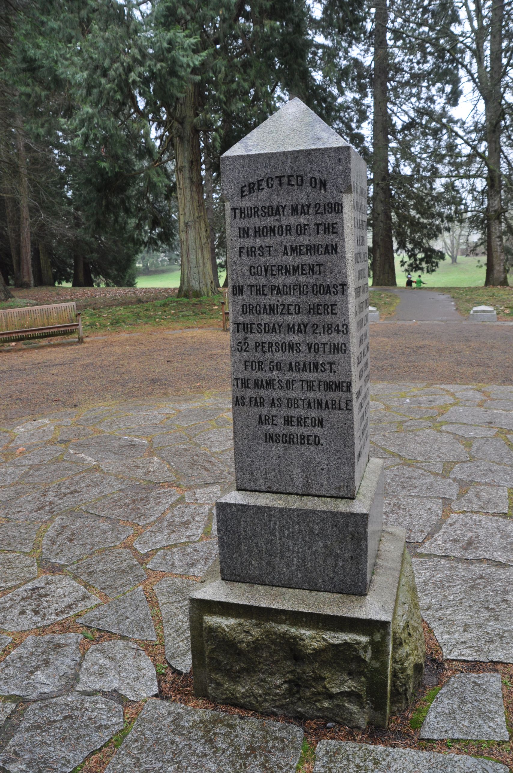
At the location where the vote was held, a granite marker is placed. The monument was installed in 1901 and attended by Francis Xavier Matthieu, one of the 52. It was a very busy spot when we were there, since the Champoeg 30K run was in progress in the wicked cold rain. The monument site was also the race finish, and it was filled with the usual tents with music playing and freebies like keyrings and energy bars, and inside the Pioneer Memorial Pavillion, water bottles and pies were being handed out to runners.

The pies made our mouths water, so we headed into Newberg to look for food. We finally found a good restaurant on the highway south, toward our second park. After we ate a stone-baked pizza and some soup to ward off the unpleasant weather, we went south again.
Along the way, we went through the cute little town of Dayton, Oregon, and Arno spotted a blockhouse in the city park. The design of this one is so clever. By rotating the upper story 45 degrees, it provides better cover for the rifles inside. “No blind spots at the corners,” Arno pointed out.
The blockhouse was in a different site originally. It was near the Grand Ronde reservation. See, when increasing numbers of Indians were hauled in, the local whites feared they would revolt. So, this blockhouse was built and put on a hill to defend the whites from the Indians (who, I might add, would have nothing to revolt against if they hadn’t been put there in the first place). In 1911 the blockhouse was brought to Dayton to be placed into the city square, carried by <slaps self on forehead> Indians with wagon teams.


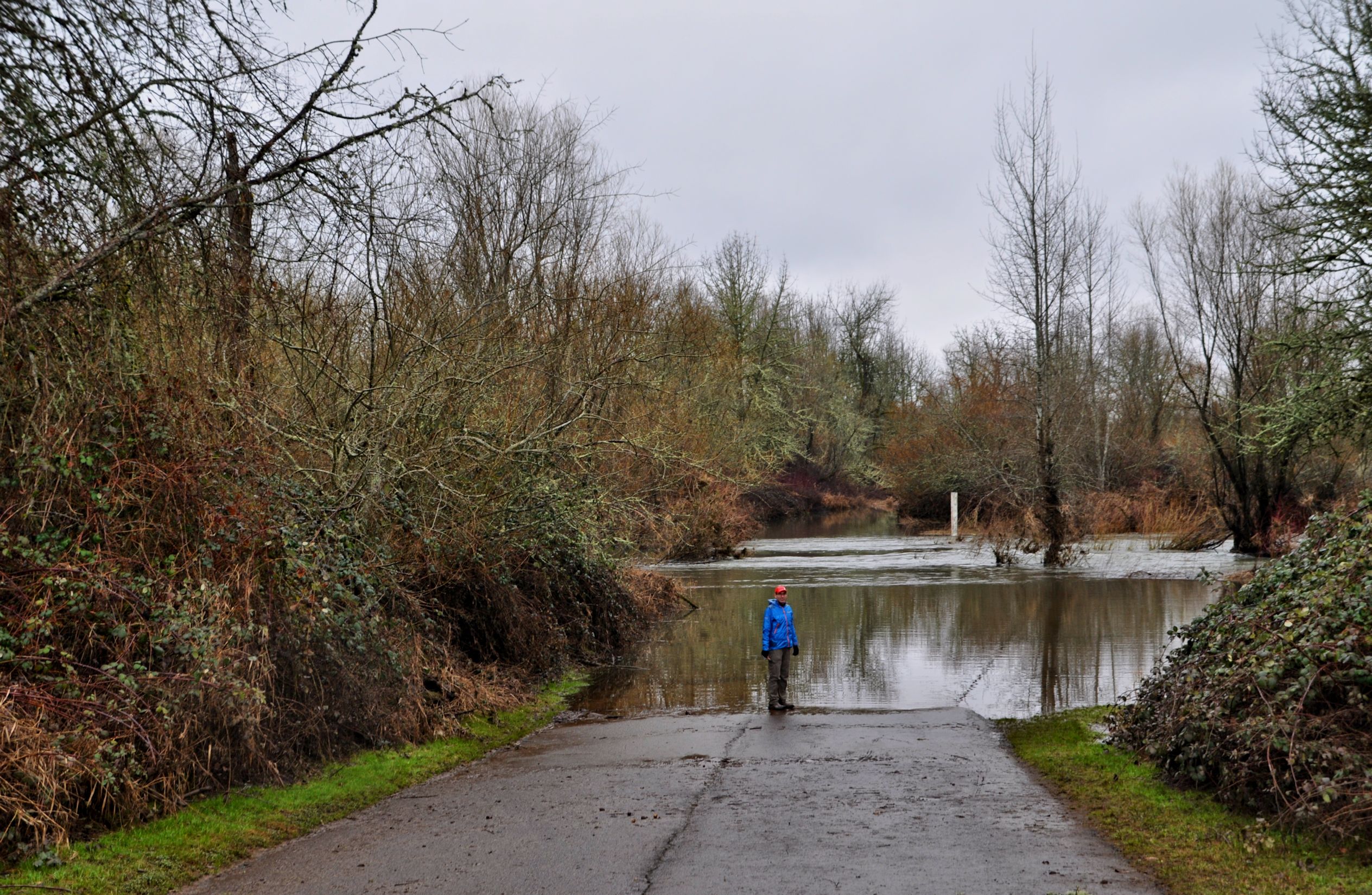
Suddenly, we were in line to get onto a ferry. A ferry! I didn’t even know there was a ferry across the Willamette till this trip. Walking through Champoeg Park it had seemed that the river was high, but here we could tell without a doubt that the river had overflowed its banks. We pulled in behind a small trailer of cattle. Our ferry ride went smoothly, as we were drawn along by cables. I was as excited as a little kid. That’s what discovering something totally unexpected will do to me.
Next we arrived at Willamette Mission State Park. Missions are another thing I hadn’t previously associated with Oregon. The mission here was established in 1834 by Reverend Jason Lee. Interestingly, he had been sent by the Methodist Church in response to a request from Nez Perce and Flathead Indians who wanted some of the power of the “white man’s book of heaven” for their own people. Lee established his mission amongst the Kalapuya (nowhere near Nez Perce or Flatheads) and was almost completely ineffectual with the Indians. When more and more white settlers arrived, Lee gave up on the Indians and began ministering to the white folks.
The 1861 flood wrecked the mission too, but not Lee’s legacy. He was instrumental in the establishment of the state of Oregon, by building the area’s first school and founding the city of Salem, now our state capital.
Just beyond the first parking area, the road was gated, with a sign that the road was closed due to high water. We were content to park there and walk into the park. The park maps here show all the old meandering arcs that used to be riverbed before the river changed its course. You can see different routes happened at different times. History made so very clear. If only the founders of Champoeg had access to an aerial map.


We walked along the Willamette Vision Educational Trail. It was pretty muddy and not too remarkable, but we were happy to walk along and read the tree identification plaques. We startled a rabbit at one point, but stood very still until he came back out beside the path to munch leaves again.

This park hosts the nation’s largest Black Cottonwood Tree. I had been very eager to see the Oregon Heritage Tree but was disappointed with this one. Possibly because I have lived in redwood country, possibly because it’s winter and the tree looked lifeless, but it’s not impressive to look at. It is believed to be 270 years old, measured at 155 feet tall with a circumference of 26 feet.
We reconnected with the paved road, and immediately saw why the road was closed. The path of the water here mimics a river, and this is what I was talking about with the map: it’s a historic path of the Willamette. Not the river, but a narrow curved lake on mild weather days. This day the water was raging through, however.
Our trail passed beside it uninterrupted, and we continued on. Soon we were back at the car again. It was time for us both to get back to our children. Miss Tara had spent most the day in Wilsonville for “Battle of the Books,” an academic competition where students read from a book list and then compete with quiz questions about the books. I had been receiving texts and knew they almost made it to the final round, so her team had done really well this year. What a great kid. I’m so proud of her! Arno’s boys were out in The Hood (what we call Hood River) and hungry. Though they can cook for themselves, they knew Dad would be showing up eventually to do it for them. Ha ha. We were close to I-5, so in minutes we were flying north again through the rain.


Good for you to get out on a less than perfect day. I love all the green grass and daffodils. The Bunny is so sweet too
I was surprised the rabbit came back out to the path when we stopped walking. I made Arno wait till I could get a good shot. He’s so good.
Yes, rainy days are the hardest to play in, I think. Snow is at least dry. And the daffodils! Even if they were down in the warmer valley, it makes me so happy to see them. Spring will come soon for me. I’ll try to write about warmth for you up in the wintry north, so you can remember what it’s like. 🙂
Oh, yes please do! I will watch for that 😀 Is Arno your doggy? Buddy would have been long gone and I’d be left whistling. What a good boy.
Ha Ha ha! Boomdee, Arno is my boyfriend! But funny you should ask, because I tease him for being as happy and bouncy as a puppy sometimes, and when he’s really happy, he sends me text messages that say “wag.” I am a bossy woman and he lets me think I’m in charge all the time, that’s what I mean when I say he’s so good.
These are my favorite kind of travel days: unexpected things (the ferry), a lot of history (love the story of the 52-50 vote), and plenty of nature. I so enjoy your explorations with Arno!
Thank you Laurie. I have noticed you like history too. It helps me remember what I learned when I write it down in my blog. Also, I have to look stuff up to make sure I get the details right, and I always end up learning more. I think when I retire I’ll go get a PhD in something, just so I have an excuse to do 10 years of research! ha ha