
{as always, click any photo for a larger version}
I woke before the sun and the first thing I did was check the sky: clear! I could see the moon. It was almost too good to be true. I was so excited I got up and got dressed but still couldn’t really do anything because everything in camp was SOAKED so I couldn’t break camp. It was even wet inside the tent, though I had remained dry and snug as a bug. I brewed myself a thermos of Peets and studied a map of nearby trails.

As the sun came up, I was treated to picture postcard views in all directions. Rabbits hopped around camp, nibbling on grass. The heat from the rising sun warmed the water on the earth, which subsequently rose into a thickening cloud cover and fog…but with continued warmth, it all evaporated. A park employee stopped by to check a tiny pond I had not yet noticed. She said the Boy Scouts built it for coyotes and deer and other animals to get a drink. She also filled the bird feeder. As soon as she left, the birds flocked in to get some breakfast and take a bath in the drinking water. I entertained myself watching wildlife while I waited for my camp gear to dry out enough to pack it up.


I chose the Siphon Draw trail, and hiked two miles up to the basin, at 3100 feet. The day grew warmer and I ended up in shorts and a tank top. Imagine! I had a blast trying to take a photo of the zillions of hummingbirds up there, but failed at it. There was a trickle of a waterfall into a pool in the basin. I’ll bet that it is dry most of the year, so I suppose I am lucky for the rain because I was able to see water flowing here.


The sun was delicious and I lollygagged to the extreme, taking about three hours to wander up the mountain and then back down again. But when I reached the bottom, the dragon wagon was all packed and ready to go, so off I went. I saw on the map that Highway 88, the one I used to get to the park, would eventually reconnect back to Hwy 60 east, so I decided to continue on the back roads rather than retrace my steps back to the busy highway I left the day before. That decision MADE my whole trip!

Highway 88 is nonstop astonishing views. Those 70 miles took me another four hours, because I stopped for several mini-hikes and dozens of roadside photo ops. By the time I reached Globe that evening, I was whooped. At one point, the road was no longer paved. Frantically I checked my topo map, and sure enough: dirt road for 22 miles. But at that point I was committed, so I plunged on. My little Saturn has off-roaded plenty of times on my watch, so it is familiar territory. The road turned out to be in darn good shape for a remote dirt road through the mountains. I laughed to think that only in the Wild West do you have a state highway that is a dirt road. Well, I know Vermont has them too, so I guess it’s a sign of a rural area: dirt highways.


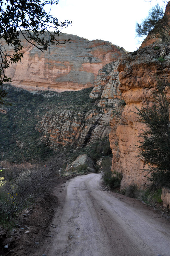

The only time I was nervous was when the road goes through a wash at Tortilla Flat. Running water was moving across the road, and I knew from my career as a weather forecaster that one should never drive through moving water. But I could see wet tracks where other vehicles had done it, and I was a couple hours into the journey at that point. I splashed through and was on my way again in a blink.
At the point where the road became paved again, I came upon a huge dam. Built in the same fashion as Hoover Dam, the Theodore Roosevelt Dam was almost as impressive because I had never heard of it and was not expecting it. This dam was built from 1903 to 1911 (Hoover Dam was begun in 1931), and at the time of completion it was the largest masonry dam in the world at 723 feet long and 280 feet high. Theodore Roosevelt Lake behind it was for a time the world’s largest artificial reservoir.

I climbed over a railing to get a better photo, and a helicopter chopped loudly right up behind me and landed right at the base of the dam, out of sight. It looked like a private helicopter, so I couldn’t guess what was up. The blades never stopped, and after a few minutes it lifted and disappeared back the way it had come. Ahhh, I enjoyed the feel of pavement under the wheels as my little car and I climbed above the dam. I crested the top and was surprised by another engineering marvel: a glorious arched bridge, eggshell blue, framed by the blue Theodore Roosevelt Lake. Wow! All this architecture and engineering and no people to appreciate it. Seems almost like a waste all the way out there in the desert.

I pulled into the Tonto National Monument, and was both disappointed and pleased that it was closed for the evening. The sign said “cliff dwellings,” but I was not aware of any cliff dwellings around here. Disappointed not to have another adventure, but pleased to be released to find a hotel instead.
(Sorry about all the pictures, I just couldn’t help myself. I took 200 today, you should be grateful for how many I did not include!)

Very, very cool video of WWI bombers… that are flying over the exact terrain I gaped at today. It’s worth watching!
Thanks to Ray for pointing out the link to this great collection of photos documenting the construction of the dam. https://www.srpnet.com/gallery/trd/1900.aspx
I laughed at the last bit. Never be sorry for the photos you take and show us. ❤
Awww, I love that you went to read this one. It was a magical day for me that I will never forget.